AOSC researchers use novel satellite based wind and rainfall products to study the wind and freshwater forcing of the tropical ocean. Bi-weekly wind and rainfall oscillation in the West African Monsoon. Enhanced spatial and temporal resolution of the satellite sensors provides better insight into the instraseasonal time scales. With the QuikSCAT scatterometer winds and rainfall estimates from the Tropical Rainfall Measuring Mission (TRMM) we have observed a new type of intraseasonal, biweekly oscillation in the West African Monsoon. This oscillatory regime precedes rainy season in subSaharan West Africa that begins in boreal summer and whose arrival is of critical importance for local economies.

Two-day average surface winds and rainfall obtained from scatterometry and TRMM microwave measurements are illustrated above. The left panel shows 16-18 May. The right panel shows 21-23 May. Rates exceeding 0.5 mm/hr are shaded. Note the rapid change in direction and rainfall pattern. This pattern has switched back by 30 May. This oscillation in rainfall occurs in conjunction with monsoonal wind patterns and is particularly noticeable in the zonal wind field. It is also associated with a cooling of surface temperature and a reduction in zonal surface pressure gradient. Together the phasing of these variables implies feedback cycle acting between the monsoonal winds and their clouds, soil moisture and surface temperature. For more details go to rainfall.
|
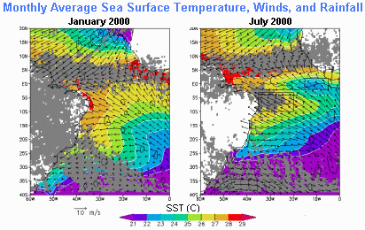
The same satellite based data have been used to investigate the existence and dynamics of a Southern Hemisphere partner to the Inter-tropical Convergence Zone (SITCZ) in the tropical Atlantic Ocean. |
 |
| Monthly average SST (colors), winds (vectors), and rainfall exceeding 2 mm/day (gray) for January, 2000 and July, 2000. Wind divergence is contoured at two levels -5*10-6 1/s and 5*10-6 1/s with dashed and solid lines, respectively. The SITCZ index region (350W-200W, 100S-30S) and the cold tongue region (150W-50W, 20S-20N) are indicated by rectangles. It extends eastward from the coast of Brazil in the latitude band 100S - 30S and is associated with seasonal precipitation exceeding 6 cm/month during peak months over a part of the ocean characterized by high surface salinity. It appears in austral winter when cool equatorial upwelling causes an anomalous northeastward pressure gradient to develop in the planetary boundary layer close to the equator. The result is a zonal band of surface wind convergence and rainfall accompanied by a decrease in the ocean surface salinity. |

