

Cloud microphysics plays a dominant role in modulating radiation fluxes in the atmosphere and precipitation processes, two important influences governing weather and climate. Drs. Chang and Li developed a new remote sensing algorithm that can determine the vertical profile of droplet effective radius and liquid water path, using multi-spectral near-IR reflectances measured by the Moderate Resolution Imaging Spectroradiometer (MODIS).
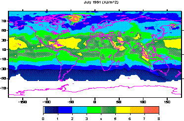 |
Ozone depletion has caused many concerns regarding the potential increase in harmful ultraviolet radiation reaching the Earth’s surface. Satellite observation offers a practical means of monitoring any changes in UV radiation on a large scale. Dr. Li’s team developed an efficient satellite inversion algorithm to estimate UV radiation and dose rate. They applied the algorithm to historical ISCCP-D1 and TOMS data and generated a long-term (~20 years) global climatology of surface UVB and dose rates. ISCCP data provides TOA reflectance measurements at a time interval of every 3 hours, and thus better accounts for the diurnal variation caused primarily by clouds while the TOMS platform provides column-integrated ozone amount. |