AI-Generated Iceberg Models Could Help Sailors Navigate Arctic Waters
Cy Keener could see only the tip of the iceberg.
For years the University of Maryland associate professor of art had voyaged to the Arctic to gather the raw material for his digital artwork: data about its melting sea ice and shifting icebergs, collected using drones and computer software. But his visual interpretations captured just the matter above water, not beneath.
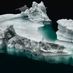
Keener, whose background includes some engineering, longed to create a rendering from top to base. It would be more than eye-catching or thought-provoking; it could also help scientists predict the path of icebergs, and mariners navigate ice-choked waters more safely.
He dispatched underwater drones during two trips to Alaska last year to collect underwater imagery of ice. Both outings were disasters. The cameras couldn’t see through the turbid waters.
“We’re taking all the pictures we can, and they didn’t add up to anything,” Keener recalled.
Now, however, Keener has reason to be hopeful...
- Log in to post comments


